

-
Recent Posts
Categories
-
Join 3 other subscribers
http://inws.wrh.noaa.gov/weather/alertinfo/3596363
Yikes! Now thats a warning area! It’s essentially the entire metro. The storms yesterday that formed out of the same pattern had quite the gust front (30mph+) so better safe than sorry right?! Expect heavy wind, blowing rain, some limited CG lightning and better stay inside for lunch.
70% chance of thunderstorms have been announced for the SE Florida region by the Miami NWS office. All week we have been in a general SSW-SW flow at the surface which will enhance the seabreeze, and push any storms that form generally to the NE. This has resulted in daily rains and thunderstorms earlier this week, and the pattern is expected to continue for the next few days.
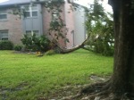
I’ll update this post as I gather videos, pics, etc from public places. For now, the official report from NOAA regarding this rare summertime Florida tornado.
Click to access TamaracTornado.pdf
The twister started out as a heavily rotating wall cloud at University/Commercial:
The funnel formed and dropped very near my own home, our neighborhood had some superficial damage, and some trees downed. This video shows the tornado as it was skipping across my apt complex, the videographer is about 3 blocks SSE:
Some photos of the damage at this pre-touchdown phase (most of this is due to the strong downburst):


Yesterday had widespread storms across most of the metro, including a very nice storm over Weston which prompted a significant weather event advisory from the Miami NWS office. There was some limited street flooding in the NW suburbs from the afternoon storms as the SB initiated storms came in, and later teh outflow initiated storms moved around the area. The flow was from the SSE, thus storms slowly drifted NNW across the metro areas. Today should be a repeat of this event with a little more convective action, and a little more moisture than yesterday. Upper air plots show 650-350mb layer flow from the NW, while below that is mostly from the south and SW. Surface winds are light from the SSE, but they are moving around to the west. This means storms are likely to be sheared unusually today, and more likely to remain near the coast.
Invest 91L has been teasing us with development potential for days now. Convection had been pulsing up and down, circulation centers have been bouncing around, becoming unstacked, tilted, sheared away – and yesterday while crossing Martinique, the hunters found her to have a low-level circulation. Winds are at about 45kts at flight level, so the NHC classed her at 8pm as a full-fledged storm with 40mph winds.
She will not have an easy time. She has entered the graveyard, so named because the persistent easterlies in this region have stymied, sheared apart, unstacked, and otherwise decimated even full-fledged hurricanes that enter the area west of the Lesser Antilles. Her next target appears to be Hispaniola – where the landmasses high rugged mountains are likely to disrupt her circulation. Should she survive all that – the Bahamas await. The crystal clear shallow water is like jet fuel to storms. The deeper waters near the Florida coast are bathtub warm to a significant depth fueled by the jetstream, so the only inhibitor would seem to be the upper atmosphere environment.
Emily is progged to find a weakness in the Atlantic ridge and nudge her way around it. Models have been sniffing out a recurve scenario near the eastern coast of FL for days now. The question being where the recurve occurs. Models this morning have shifted west with the BAMS showing a gulf storm, while the GFS and UKMET stay east of FL. We need more time and more model runs to hammer this track out.
Today has us in the throes of the Easterlies. Well south-easterlies. This will deign to bring us more heat and humidity, but the light nature of these winds will mean any storms that form will stay put. In the upper atmosphere, the winds remain fairly strong from the east. This means the storms will be sheared and thus can become strong. There is enough instability in the atmosphere (in sfl, this means no subsidence or significant inversion exists), and PWATS hovers around 2″. This is a recipe for SB storms this afternoon which might start a bit earlier due to the light low level flow.
NHC is likely to call TD4 in just a little while. Recon data supports the upgrade to at least a depression, maybe a storm named Don. He’s headed for Texas.
TROPICAL WEATHER OUTLOOK
NWS NATIONAL HURRICANE CENTER MIAMI FL
200 PM EDT WED JUL 27 2011
FOR THE NORTH ATLANTIC…CARIBBEAN SEA AND THE GULF OF MEXICO…
SATELLITE IMAGERY INDICATES A TROPICAL DEPRESSION OR TROPICAL STORM
COULD BE FORMING ABOUT 90 MILES NORTH OF CANCUN MEXICO. AN AIR
FORCE RESERVE HURRICANE HUNTER AIRCRAFT IS CURRENTLY ENROUTE TO
INVESTIGATE THE AREA…AND IF IT CONFIRMS THE PRESENCE OF A
CIRCULATION…ADVISORIES WILL BE INITIATED THIS AFTERNOON.
INTERESTS IN THE CENTRAL AND WESTERN GULF OF MEXICO SHOULD MONITOR
THIS SYSTEM AS IT MOVES WEST-NORTHWESTWARD NEAR 15 MPH. THIS
SYSTEM HAS A HIGH CHANCE…NEAR 100 PERCENT..OF BECOMING A TROPICAL
CYCLONE DURING THE NEXT 48 HOURS.
ELSEWHERE…TROPICAL CYCLONE FORMATION IS NOT EXPECTED DURING THE
NEXT 48 HOURS.
$$
FORECASTER BEVEN
The past few days have seen fabulous storms blow up over most of the East Coast Metro (see the pics!) These storms have been moderately active electrically and contained a significant amount of rain. There was a classic gust front blow through on Tuesday over Tamarac prior to a massive precip event. Both Tuesday and Wednesday had storms that generated a nice wall cloud (no real rotation but very convectively active) with a tail.
I’m watching a wave in the central Atlantic that has some varied model support. Its embedded in a very nic plume of moisture, the MIMIC-TPW signature of the wave is very strong, and if this were September, we’d already have a CAT2 cane coming across. However as its still July – the upper environment is not quite ther yet, and the SST’s, while warm, just aren’t as strong as they need to be to develop. This wave is progged to come across the Leewards, into bahamas, and then perhaps across South FL. Several (fantasyland) model runs showed the Katrina solution across SFL (that is exist as a wave for a very long time, generate into a TS over the Bahamas, and get pushed back WSW across SFL as a strengthening hurricane. I’m praying this solution does not come to fruition, as its still too early for this!
